USE CASE
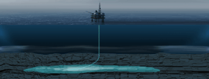
CCS site characterisation and de-risking
Analyse reservoir properties and associated risk for CCS sites
After the initial screening process, you need to perform a detailed analysis of the reservoir properties and associated risks for the candidate sites identified. Reservoir characterisation and de-risking requires significant manual analysis by highly skilled professionals, utilising all relevant datasets including seismic data to determine the feasibility of developing a secure and stable storage site for CO2.
The goal is to ensure that CO2 is captured and stored in an environmentally isolated and stable storage system, which is essential for the success of carbon capture and storage (CCS) efforts. Any leaks could pose a significant risk to human health and the environment, as CO2 is a greenhouse gas that contributes to climate change.
Why you need AI-driven geoscience software
When you are looking for sites to store CO2, you need to screen large areas efficiently. Increase speed more than 10X by leveraging AI instead of traditional methods.
Healthy project economics for CCS requires that we find ways to keep costs down. AI software can assist geoscientists to reduce basin screening cycle time from years to months.
By using AI models trained on vast amounts of QC'ed data, you reduce the human bias and subjectivity associated with traditional methods, thus increasing the accuracy of the interpretation.

Drastically reduce time spent searching for data
Traditionally geologists use well- and seismic data to evaluate large areas and identify potential candidates for storage sites. These processes require considerable resources and expertise in multiple fields, and the work is highly manual, making it a time-consuming and labor-intensive endeavor.
Characterise and de-risk carbon storage sites with EarthNET
Our solution has the capability to efficiently analyse data during the characterisation and de-risking process, and in fact, having a larger amount of data to process can lead to more precise results when utilising the full range of our advanced software EarthNET.

Rapid, data-driven structural seismic interpretation
Interpreting seismic data to map the reservoir's geometry, structure, and layering is crucial for understanding storage volume and sealing capacity for potential CO2 storage sites.
EarthNET Seismic Interpretation dramatically increases the efficiency of seismic interpretation by utilising AI. By applying AI models, you can reduce your workflows from weeks and months to days while simultaneously improving the quality of interpretation.
Disover the capabilities of EarthNET AI Seismic interpretation →
Class-leading 3D reservoir property prediction
Quantifying the reservoir's properties is essential for populating geocellular models for volumetric calculations and flow simulation studies for characterisation and de-risking of carbon storage sites.
EarthNET AI Seismic properties has revolutionised the seismic property prediction process into one seamless workflow using AI. You can now create a 3D property cube in a matter of weeks, which would be impossible using the traditional seismic inversion workflow.
Explore EarthNET AI Seismic properties →


Use all available data to form the basis for your decision-making
The traditional expert-driven approach to decision-making in CCS context is likely to be subjective and prone to human biases, resulting in less accurate geomodels.
With EarthNET Insights, all available data is utilised to deliver fully auditable, reproducible, and cost-effective insights at scale. It provides a complete and purely data-driven basis for volumetrics and uncertainty estimations to form the basis for your CCS site development decisions.
Explore EarthNET Insights →
“By utilising ESA’s deep domain expertise in both geoscience and deep learning technology, we were able to augment a sparse dataset over the area of interest with additional relevant geological data. With its EarthNET technology, ESA captured regional trends in geology, quantified the full range of uncertainty within acoustic and physical properties, and provided a data-driven model that challenges underlying assumptions within traditional workflows. “
Learn more about our products and services
EarthNET
Our groundbreaking suite of geoscience tools leveraging cloud-technology, high performance computing, and artificial intelligence to liberate your subsurface data and innovate your workflows.
Explore →
Consulting Services
Our expert team is here to guide you every step of the way, whether you're just starting out with AI and machine learning or looking to integrate EarthNET into your existing operations.
Explore →
Multi-Client Products
With our data packages, you get access to cleaned, indexed, contextualised, and interpreted data that can be plugged directly into your geoscience workflows, saving you time and resources.
Explore →
Get in touch
We are dedicated to helping our clients unleash the full potential of their data.
Let's talk about the opportunities, and explore how we can assist you.

